What is situational awareness?
Situational awareness for incident response and event management involves real time information in three interdependent areas of focus.
1. Awareness of the environment
2. Comprehension of the situation
3. Projections of future states
Awareness of the environment
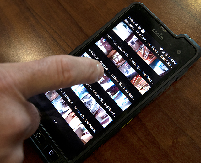
The availability of environmental information is growing every day. Smart devices, vehicles, buildings and cities collect data from an array of sensors, systems, people, cameras and data stores. Three groups of solutions in the FirstNet App Catalog contribute to gaining an awareness of the environment.
-
External awareness
Growing collection of apps that enable communication and data sharing with cameras, IoT devices, fleet trackers, emergency facilities and field personnel.
-
Community engagement
Innovative solutions that provide actionable information when and where you need it. Ground truth from on-scene civilians and life-saving information about the people you encounter.
-
Communications
Real time location and status of emergency personnel, assets and facilities provides vital incident and event management awareness.
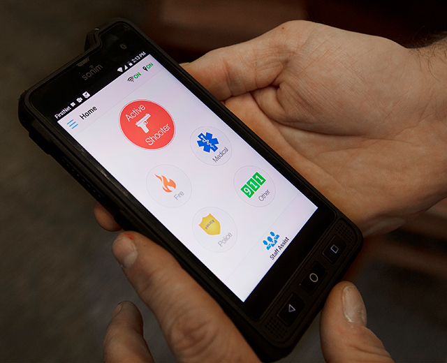
Comprehension of situation
Gleaning understanding and meaning from all the noise and environmental feeds of data can prove challenging. The App Catalog includes solutions that organize and present relevant information for rapid decision-making and coordination of activities.
-
Operating pictures
Some apps fuse and analyze collected information to organize and present the information in common operating pictures with dashboards and maps to enhance quick understanding.
-
Mission execution
Many apps modernize and digitize daily activities for public safety disciplines. Streamlining documentation, making it easier to retrieve relevant information quickly. You can find apps designed for law enforcement, fire and rescue, patient care, and school safety.
-
Responder resources
Emergency response and event planning and management requires creating, referencing and sharing documents such as Field Operation Guides. The App Catalog has resources that help.
Projection of future states
Projecting the likelihood of various future states is a regular part of public safety activities today.
-
Weather Forecasts
Weather forecasts help firefighters establish control lines for wildfires. And weather predictions are used by unified command to define fume parameters for HAZMAT incidents.
-
Virus Spread
COVID-19 transmission and spread history and projections are used to predict healthcare response needs.
-
Crime Predictions
Law enforcement officers may alter their patrol in response to hot spot trends and crime predictions.
-
Accident Trends
Water rescue personnel may be staged near a popular lake on the first warm day based on past drownings. And roadway crews may stage equipment based on traffic accident predictions.
Some App Catalog solutions and FirstNet features can help:
-
Operating picture apps
When some of these apps fuse and analyze collected information they can consume and present data over time or some criteria such as weather and neighboring jurisdictions.
-
Mission execution apps
By digitizing operational information, historical data about places, people and things can be more easily incorporated into analytical models.
-
FirstNet Central
FirstNet Central can also help. FirstNet works with Esri, the world leader in GIS solutions, to provide FirstNet users with an ever-growing series of relevant map layers.
Learn more
App uses & benefits
*App descriptions and information contained in any linked materials about the apps are created by the app provider and, as such, AT&T and FirstNet do not assume responsibility for the content.
LEARN ABOUT AMERICA'S PUBLIC SAFETY NETWORK
Get connected
By clicking Submit, you consent to AT&T sending you email about FirstNet services, products and offers at the address you provide, even if you have previously opted out of receiving AT&T marketing emails.
By clicking Submit, you consent to AT&T sending you email about FirstNet services, products and offers at the address you provide, even if you have previously opted out of receiving AT&T marketing emails.